
Image: H1N1 map

Size of this PNG preview of this SVG file: 800 × 406 pixels. Other resolution: 320 × 162 pixels.
Original image (SVG file, nominally 940 × 477 pixels, file size: 1.28 MB)
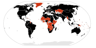
Description: A map of the infected countries of the H1N1 flu of 2009. confirmed death and infections confirmed infections unconfirmed infections The map can be edited very rapidly because it is a current event which is changing hour by hour.
Title: H1N1 map
Credit: Own work by uploader, used File:BlankMap-World6, compact.svg as original template. Although, many other users uploaded another version over it.
Author: Allstrak
Usage Terms: GNU Free Documentation License
License: GFDL
License Link: http://www.gnu.org/copyleft/fdl.html
Attribution Required?: Yes
Image usage
The following page links to this image:

All content from Kiddle encyclopedia articles (including the article images and facts) can be freely used under Attribution-ShareAlike license, unless stated otherwise.