Image: GrandeSomaliasettembre1940
GrandeSomaliasettembre1940.gif (416 × 320 pixels, file size: 11 KB, MIME type: image/gif)
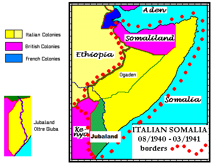
Description: Map of Italian Somalia after the conquest of British Somaliland (in August 1940) and areas around Moyale/Buna in Kenya (in July 1940). Within the green line is Ogaden, annexed from Ethiopia in 1936. The red dotted line encircles Mussolini's "Grande Somalia", that lasted from August 1940 to March 1941 under governor De Simone.
Title: GrandeSomaliasettembre1940
Credit: Own work
Author: Duilmodena
Usage Terms: Public domain
License: Public domain
Attribution Required?: No
Image usage
The following page links to this image:

All content from Kiddle encyclopedia articles (including the article images and facts) can be freely used under Attribution-ShareAlike license, unless stated otherwise.

