
Image: GeomagCoords
No higher resolution available.
GeomagCoords.png (403 × 273 pixels, file size: 2 KB, MIME type: image/png)
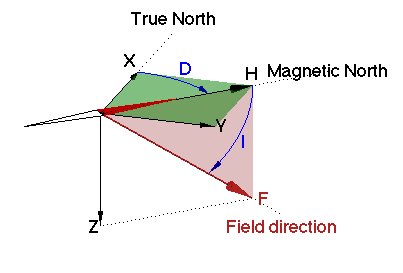
Description: Illustration of the coordinate systems used for representing the Earth's magnetic field. The coordinates X,Y,Z correspond to North, East and down; D is the declination and I is the inclination. The declination is measured first using a compass and then the inclination is measured while facing magnetic north.
Title: GeomagCoords
Credit: Own work
Author: RockMagnetist
Usage Terms: Creative Commons Attribution-Share Alike 3.0
License: CC BY-SA 3.0
License Link: https://creativecommons.org/licenses/by-sa/3.0
Attribution Required?: Yes
Image usage
The following page links to this image:

All content from Kiddle encyclopedia articles (including the article images and facts) can be freely used under Attribution-ShareAlike license, unless stated otherwise.