
Image: GallicEmpire262

Size of this preview: 570 × 599 pixels. Other resolutions: 228 × 240 pixels | 3,582 × 3,766 pixels.
Original image (3,582 × 3,766 pixels, file size: 638 KB, MIME type: image/png)
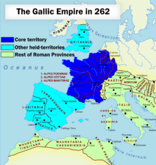
Description: Map of the rebellous Gallic Empire, showing its core areas and held territories, within the Roman Empire, in 262.
Title: GallicEmpire262
Credit: Original map being RomanEmpire 117.svg + my own edit.
Author: Original - ArdadN ; edit - Wario2.
Usage Terms: Public domain
License: Public domain
Attribution Required?: No
Image usage
The following page links to this image:

All content from Kiddle encyclopedia articles (including the article images and facts) can be freely used under Attribution-ShareAlike license, unless stated otherwise.