
Image: French Soudan 1889

Size of this preview: 800 × 523 pixels. Other resolutions: 320 × 209 pixels | 2,738 × 1,791 pixels.
Original image (2,738 × 1,791 pixels, file size: 2 MB, MIME type: image/jpeg)
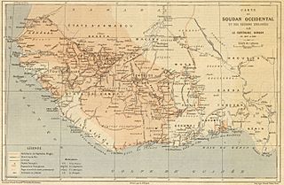
Description: Map of the French Sudan (modern day Mali) published in Le Temps in March 1890 to illustrate an account of the 1887-1889 voyage of Captain Binger. (See also File:Soudan français-Binger.jpg)
Title: French Soudan 1889
Credit: Bibliothèque nationale de France
Author: Emile Giffault, born 1850 (map)
Usage Terms: Public domain
License: Public domain
Attribution Required?: No
Image usage
The following page links to this image:

All content from Kiddle encyclopedia articles (including the article images and facts) can be freely used under Attribution-ShareAlike license, unless stated otherwise.