Image: Fort-blount-layout-tn1
Fort-blount-layout-tn1.jpg (370 × 230 pixels, file size: 17 KB, MIME type: image/jpeg)
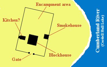
Description: Layout of Fort Blount in Jackson County, Tennessee, USA, as determined by archaeological excavations conducted 1989-1994. This map is not drawn to scale. The fort was appx. 220 ft (67m) from the modern lakeshore. The walls of the fort measured appx. 115 ft (35m) by 80 ft (24m). This map is based on Smith, et al., An Archaeological Interpretation of the Site of Fort Blount (2000), p. 133.
Title: Fort-blount-layout-tn1
Credit: Own work
Author: Brian Stansberry
Usage Terms: Public domain
License: Public domain
Attribution Required?: No
Image usage
The following page links to this image:

All content from Kiddle encyclopedia articles (including the article images and facts) can be freely used under Attribution-ShareAlike license, unless stated otherwise.

