
Image: Fire Isl-inlet Map
No higher resolution available.
Fire_Isl-inlet_Map.jpg (432 × 255 pixels, file size: 37 KB, MIME type: image/jpeg)
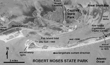
Description: Fire Island inlet Map. Aerial photograph map of Robert Moses State Park. Note the location of the end of Fire Island in 1825 when the lighthouse was built.
Title: Fire Isl-inlet Map
Credit: http://3dparks.wr.usgs.gov/nyc/parks/loc74.htm
Author: USGS
Usage Terms: Public domain
License: Public domain
Attribution Required?: No
Image usage
The following page links to this image:

All content from Kiddle encyclopedia articles (including the article images and facts) can be freely used under Attribution-ShareAlike license, unless stated otherwise.