
Image: Falkland Islands map shaded relief-en

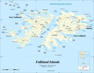
Description: The Falkland Islands are an archipelago in the South Atlantic Ocean, located 300 miles off the coast of Argentina. They consist of two main islands, East Falkland and West Falkland, together with about 700 smaller islands. Stanley, on East Falkland, is the capital and largest city. The islands are a self-governing Overseas Territory of the United Kingdom. Note : The shaded relief is a raster image embedded in the SVG file.
Title: Falkland Islands map shaded relief-en
Credit: Own work, same map as Image:Falkland_Islands_topographic_map-en.svg but without topographic and bathymetric information ; Background map : NASA Shuttle Radar Topography Mission data (public domain) edited with dlgv32 Pro/Global Mapper and vectorized with Inkscape ; Other references used for additional data : UK government map ; NASA World Wind ; CIA map available on the site of the University of Texas at Austin.
Author: Eric Gaba (Sting - fr:Sting)
Permission: Attribution and Share-Alike required Any use of this map can be made as long as you credit me (Eric Gaba – Wikimedia Commons user: Sting) as the author and distribute the copies and derivative works under the same license(s) that the one(s) stated below. A message with a reply address would also be greatly appreciated.
Usage Terms: Creative Commons Attribution-Share Alike 4.0
License: CC BY-SA 4.0
License Link: https://creativecommons.org/licenses/by-sa/4.0
Attribution Required?: Yes
Image usage
The following page links to this image:
