
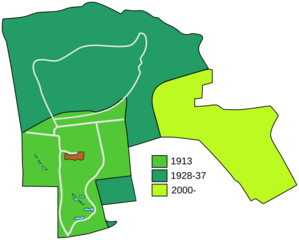
Image: Edinburgh zoo plan of land with dates of development

Size of this PNG preview of this SVG file: 746 × 600 pixels. Other resolution: 299 × 240 pixels.
Original image (SVG file, nominally 827 × 665 pixels, file size: 23 KB)
Description: A plan showing the boundaries of Edinburgh zoo, split into sections to show which areas were purchased and developed at which time
Title: Edinburgh zoo plan of land with dates of development
Credit: Created using Inkscape using information from various sources (see History of Edinburgh Zoo)
Author: Noiratsi
Usage Terms: Creative Commons Zero, Public Domain Dedication
License: CC0
License Link: http://creativecommons.org/publicdomain/zero/1.0/deed.en
Attribution Required?: No
Image usage
The following page links to this image:

All content from Kiddle encyclopedia articles (including the article images and facts) can be freely used under Attribution-ShareAlike license, unless stated otherwise.