
Image: Echo Park Dam proposal

Size of this preview: 662 × 600 pixels. Other resolutions: 265 × 240 pixels | 1,405 × 1,273 pixels.
Original image (1,405 × 1,273 pixels, file size: 2.48 MB, MIME type: image/png)
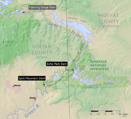
Description: Map showing the proposed Echo Park and Split Mountain reservoirs along the Green River, Colorado and Utah. The 1960s proposal would have flooded much of Dinosaur National Monument. Created using USGS digital elevation data, with Echo Park reservoir shown at the 5500' (1700m) contour and Split Mountain at 5048' (1539m). Flaming Gorge Dam, which was later built in place of Echo Park and Split Mountain, is in the upper left corner.
Title: Echo Park Dam proposal
Credit: Own work
Author: Shannon1
Usage Terms: Creative Commons Attribution-Share Alike 4.0
License: CC BY-SA 4.0
License Link: https://creativecommons.org/licenses/by-sa/4.0
Attribution Required?: Yes
Image usage
The following page links to this image:

All content from Kiddle encyclopedia articles (including the article images and facts) can be freely used under Attribution-ShareAlike license, unless stated otherwise.