
Image: Duchy of Naxos locator

Size of this PNG preview of this SVG file: 730 × 600 pixels. Other resolution: 292 × 240 pixels.
Original image (SVG file, nominally 1,510 × 1,241 pixels, file size: 151 KB)
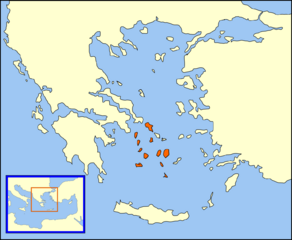
Description: A "locator" (text- and language-free) map of the Duchy of Naxos, also known as the Duchy of the Archipelago, dated approximately 1450, just before the fall of Constantinople. The English language parent map of this locator map:
Title: Duchy of Naxos locator
Credit: No machine-readable source provided. Own work assumed (based on copyright claims).
Author: No machine-readable author provided. MapMaster assumed (based on copyright claims).
Usage Terms: Creative Commons Attribution 2.5
License: CC BY 2.5
License Link: https://creativecommons.org/licenses/by/2.5
Attribution Required?: Yes
Image usage
The following page links to this image:

All content from Kiddle encyclopedia articles (including the article images and facts) can be freely used under Attribution-ShareAlike license, unless stated otherwise.