
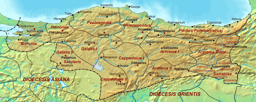
Image: Dioecesis Pontica 400 AD
Size of this preview: 800 × 319 pixels. Other resolutions: 320 × 128 pixels | 835 × 333 pixels.
Original image (835 × 333 pixels, file size: 330 KB, MIME type: image/png)
Description: Map of the Diocese of Pontus (Dioecesis Pontica) ca. 400 AD, showing the subordinate provinces and the major cities.
Title: Dioecesis Pontica 400 AD
Credit: Base map found at en:Topographic map#Global 1-kilometer map, otherwise self-made. Data based on maps in atlases and the internet and on contemporary sources, primarily the Notitia Dignitatum and the Synecdemus. Note: the exact course of the provincial boundaries is very uncertain and in many cases only approximate.
Author: Cplakidas
Usage Terms: Public domain
License: Public domain
Attribution Required?: No
Image usage
The following 2 pages link to this image:

All content from Kiddle encyclopedia articles (including the article images and facts) can be freely used under Attribution-ShareAlike license, unless stated otherwise.