
Image: DesertStormMap v2

Size of this PNG preview of this SVG file: 800 × 563 pixels. Other resolution: 320 × 225 pixels.
Original image (SVG file, nominally 1,500 × 1,056 pixels, file size: 3.13 MB)
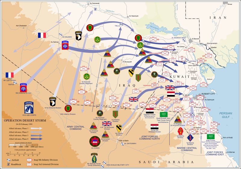
Description: Map of ground operations of Operation Desert Storm starting invasion February 24-28th 1991. Shows allied and Iraqi forces. Special arrows indicate the American 101st Airborne division moved by air and where the French 6st light division and American 3rd Armored Cavalry Regiment provided security.
Title: DesertStormMap v2
Credit: self-vectored from Image:Operation Desert Storm.jpg from this site and this site.
Author: Jeff Dahl
Usage Terms: Creative Commons Attribution-Share Alike 4.0
License: CC BY-SA 4.0
License Link: https://creativecommons.org/licenses/by-sa/4.0
Attribution Required?: Yes
Image usage
The following 3 pages link to this image:

All content from Kiddle encyclopedia articles (including the article images and facts) can be freely used under Attribution-ShareAlike license, unless stated otherwise.