
Image: Copley Square map 1874

Size of this preview: 800 × 572 pixels. Other resolutions: 320 × 229 pixels | 1,658 × 1,185 pixels.
Original image (1,658 × 1,185 pixels, file size: 1.45 MB, MIME type: image/png)
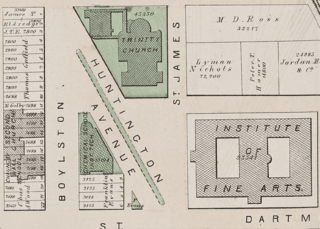
Description: Surveyor's map of Copley Square, Boston, 1874
Title: Copley Square map 1874
Credit: Map reproduction courtesy of the Norman B. Leventhal Map & Education Center at the Boston Public Library. https://collections.leventhalmap.org/search/commonwealth:tt44pv33m
Author: Griffin Morgan Hopkins, Jr.
Usage Terms: Public domain
License: Public domain
Attribution Required?: No
Image usage
The following page links to this image:

All content from Kiddle encyclopedia articles (including the article images and facts) can be freely used under Attribution-ShareAlike license, unless stated otherwise.