
Image: Conquest of Colombia route map

Size of this preview: 552 × 599 pixels. Other resolutions: 221 × 240 pixels | 644 × 699 pixels.
Original image (644 × 699 pixels, file size: 817 KB, MIME type: image/png)
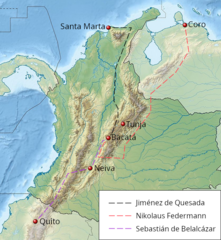
Description: Map of the approximate routes taken by Quesada, Federmann and Balalcazar in their conquest of the Muisca plateau in Colombia, 1536-39. Based on the maps and narrative found in John Hemming (1978), The Search for El Dorado, and Victor von Hagen (1974), The Golden Man.
Background is a crop of File:Colombia relief location map.jpg.
Author: Sojourner in the earth
Usage Terms: Creative Commons Attribution-Share Alike 3.0
License: CC-BY-SA-3.0
License Link: http://creativecommons.org/licenses/by-sa/3.0/
Attribution Required?: Yes
Image usage
The following page links to this image:

All content from Kiddle encyclopedia articles (including the article images and facts) can be freely used under Attribution-ShareAlike license, unless stated otherwise.