
Image: Columbiasloughwatershed

Size of this preview: 769 × 600 pixels. Other resolutions: 308 × 240 pixels | 1,539 × 1,200 pixels.
Original image (1,539 × 1,200 pixels, file size: 302 KB, MIME type: image/png)
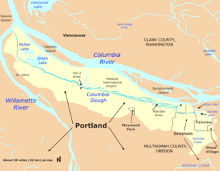
Description: Map of Columbia Slough watershed in Multnomah County, Oregon, United States. The slough begins in Fairview, Oregon, and flows into the Willamette River at Portland. The symbol P indicates a pumping station.
Title: Columbiasloughwatershed
Credit: Taken from U.S. Census website here and modified by User:Finetooth. Watershed boundaries from Portland Bureau of Environmental Services here and Columbia Slough Watershed Council here.
Author: U.S. Census, Finetooth
Permission: U.S. government work in public domain; my modifications licensed under GFDL, CC-BY-SA-3.0
Usage Terms: Public domain
License: Public domain
Attribution Required?: No
Image usage
The following 2 pages link to this image:

All content from Kiddle encyclopedia articles (including the article images and facts) can be freely used under Attribution-ShareAlike license, unless stated otherwise.