
Image: Cluanie Horseshoe

Size of this PNG preview of this SVG file: 611 × 600 pixels. Other resolution: 245 × 240 pixels.
Original image (SVG file, nominally 745 × 731 pixels, file size: 157 KB)
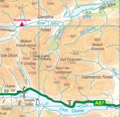
Description: Map of "Cluanie Horseshoe", mountain range between Glenmoriston and Glen Affric in the Northwest Highlands of Scotland. Munros in the ridge: Mullach Fraoch-choire, A' Chràlaig, Sgurr nan Conbhairean and Sail Chaorainn and nine other Munro Tops. This file was derived from: Ordnance Survey 1-250000 - NH.jpg .
Title: Cluanie Horseshoe
Credit: Own work and Ordnance Survey OpenData 1:250 000 Scale Colour Raster. Converted from File:Ordnance Survey 1-250000 - NH.tif
Author: Thincat and Ordnance Survey
Usage Terms: Creative Commons Attribution-Share Alike 3.0
License: CC BY-SA 3.0
License Link: https://creativecommons.org/licenses/by-sa/3.0
Attribution Required?: Yes
Image usage
The following 2 pages link to this image:

All content from Kiddle encyclopedia articles (including the article images and facts) can be freely used under Attribution-ShareAlike license, unless stated otherwise.