Image: Chunchucmil-sitecentermap

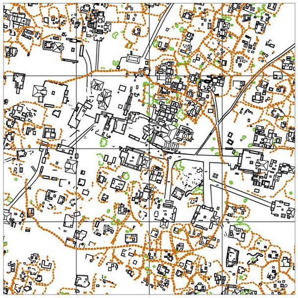
Description: Map of the ancient Maya site of Chunchucmil. This particular map covers only the central 1 km2 of the pre-Hispanic city. The orange-brown color indicates ancient stone walls. Light green indicates depressions (such as quarries or sascaberas). Black lines indicate ancient architecture.
Title: Chunchucmil-sitecentermap
Credit: Drafted by the Pakbeh Regional Economy Project (principal authors: Dahlin, Magnoni and Hutson). Transferred from en.wikipedia to Commons by User:Jalo using CommonsHelper.
Author: Principal authors: Dahlin, Magnoni and Hutson
Permission: This work is free and may be used by anyone for any purpose. If you wish to use this content, you do not need to request permission as long as you follow any licensing requirements mentioned on this page. The Wikimedia Foundation has received an e-mail confirming that the copyright holder has approved publication under the terms mentioned on this page. This correspondence has been reviewed by a Volunteer Response Team (VRT) member and stored in our permission archive. The correspondence is available to trusted volunteers as ticket #2011071310009433. If you have questions about the archived correspondence, please use the VRT noticeboard. Ticket link: https://ticket.wikimedia.org/otrs/index.pl?Action=AgentTicketZoom&TicketNumber=2011071310009433 Find other files from the same ticket:
Usage Terms: Creative Commons Attribution-Share Alike 2.5
License: CC BY-SA 2.5
License Link: https://creativecommons.org/licenses/by-sa/2.5
Attribution Required?: Yes
Image usage
The following page links to this image:

