
Image: Chumash villages

Size of this PNG preview of this SVG file: 512 × 446 pixels. Other resolution: 276 × 240 pixels.
Original image (SVG file, nominally 512 × 446 pixels, file size: 161 KB)
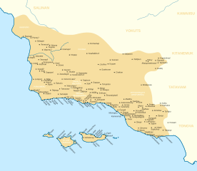
Description: Map of Chumash villages. Circles filled in white signify regional "capitals." Superscript crosses indicate mission villages. Adapted from map compiled by Chester King (1975) from the notes of John P Harrington.
https://escholarship.org/content/qt8833s5k5/qt8833s5k5.pdf
This file was derived from: USA California location map.svg
Author: Noahedits
Usage Terms: Creative Commons Attribution-Share Alike 3.0
License: CC-BY-SA-3.0
License Link: http://creativecommons.org/licenses/by-sa/3.0/
Attribution Required?: Yes
Image usage
The following page links to this image:

All content from Kiddle encyclopedia articles (including the article images and facts) can be freely used under Attribution-ShareAlike license, unless stated otherwise.