
Image: Catharus fuscescens map

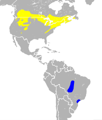
Description: Range Map for the Veery - Catharus fuscescens Breeding range Wintering range
Title: Catharus fuscescens map
Credit: range data: Veery Species Range on IUCN Ridgely et al. and BirdLife International (2012) Digital Distribution Maps of the Birds of the Western Hemisphere, version 5.0 . In BirdLife International and NatureServe (2012) Bird species distribution maps of the world. 2012. Catharus fuscescens. In: IUCN 2013. IUCN Red List of Threatened Species. Version 2013.1. http://www.iucnredlist.org. Downloaded on 10 Nov 2013. background data: TM_WORLD_BORDERS-0.1 Provided by Bjorn Sandvik, thematicmapping.org background data: Made with Natural Earth. Free vector and raster map data @ naturalearthdata.com.
Author: Stongey
Usage Terms: Creative Commons Attribution-Share Alike 3.0
License: CC BY-SA 3.0
License Link: https://creativecommons.org/licenses/by-sa/3.0
Attribution Required?: Yes
Image usage
The following page links to this image:
