
Image: Canada change 1999-04-01

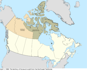
Description: Map of the change to Canada on April 1, 1999. The territory of Nunavut was created from roughly the eastern half of the Northwest Territories.[1] This was built with the shapefiles: Territorial Evolution, from the University of Toronto: https://doi.org/10.5683/SP2/IQ7E0X Global Islands: https://doi.org/10.5066/P91ZCSGM United States maritime borders: https://nauticalcharts.noaa.gov/data/us-maritime-limits-and-boundaries.html United States details from the Newberry Library: https://digital.newberry.org/ahcb/ Canada detailed administrative divisions: https://www12.statcan.gc.ca/census-recensement/2021/geo/sip-pis/boundary-limites/index2021-eng.cfm?year=21 ↑ Nunavut Act. Government of Canada. Retrieved on May 12, 2017.
Title: Canada change 1999-04-01
Credit: Own work
Author: Golbez
Usage Terms: Creative Commons Attribution-Share Alike 4.0
License: CC BY-SA 4.0
License Link: https://creativecommons.org/licenses/by-sa/4.0
Attribution Required?: Yes
Image usage
The following page links to this image:
