
Image: Canada change 1912-05-15

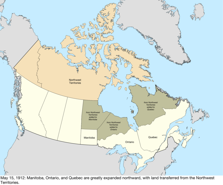
Description: Map of the change to Canada on May 15, 1912. Manitoba, Ontario, and Quebec were all expanded northward into land from the Northwest Territories.[1] Quebec was expanded north to fill the mainland, Manitoba extended north to the 60th parallel north, and the new border between Manitoba and Ontario ran northeast from the previous northeastern corner of Manitoba.[2][3] This was built with the shapefiles: Territorial Evolution, from the University of Toronto: https://doi.org/10.5683/SP2/IQ7E0X Global Islands: https://doi.org/10.5066/P91ZCSGM United States maritime borders: https://nauticalcharts.noaa.gov/data/us-maritime-limits-and-boundaries.html United States details from the Newberry Library: https://digital.newberry.org/ahcb/ Canada detailed administrative divisions: https://www12.statcan.gc.ca/census-recensement/2021/geo/sip-pis/boundary-limites/index2021-eng.cfm?year=21 ↑ History of the Name of the Northwest Territories. Prince of Wales Northern Heritage Centre. Retrieved on October 17, 2015. ↑ Manitoba Boundaries Extension Act, 1912. solon.org. Archived from the original on November 11, 2020. Retrieved on October 3, 2023. ↑ Ontario Boundaries Extension Act.
Title: Canada change 1912-05-15
Credit: Own work
Author: Golbez
Usage Terms: Creative Commons Attribution-Share Alike 4.0
License: CC BY-SA 4.0
License Link: https://creativecommons.org/licenses/by-sa/4.0
Attribution Required?: Yes
Image usage
The following page links to this image:
