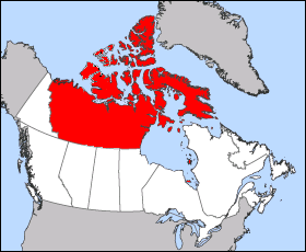
Image: Canada Provinces Territories 1949
Canada_Provinces_Territories_1949.png (280 × 230 pixels, file size: 12 KB, MIME type: image/png)
Description: Images was created from en:Image:Northwest Territories-map.png to over come objections, please improve this map on anyway you see fit. This map is the boundaries of the Northwest Territories from 1912 to 1999. The Map is of 1949 Canada boundaries as Newfoundland and Labrador entered the union, this change had no effect on the Northwest Territories.
Title: Canada Provinces Territories 1949
Credit: Transferred from en.wikipedia to Commons.
Author: Maclean25 at English Wikipedia
Usage Terms: Public domain
License: Public domain
Attribution Required?: No
Image usage
The following page links to this image:

All content from Kiddle encyclopedia articles (including the article images and facts) can be freely used under Attribution-ShareAlike license, unless stated otherwise.

