
Image: Caithness Shire 1845 parish map

Size of this preview: 498 × 600 pixels. Other resolutions: 199 × 240 pixels | 2,492 × 3,000 pixels.
Original image (2,492 × 3,000 pixels, file size: 1.69 MB, MIME type: image/jpeg)
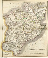
Description: Caithness Shire map with parish boundaries, also published in the The New Statistical Account of Scotland, Vol. XV, William Blackwood & Sons, Edinburgh and London 1845
Title: Caithness Shire 1845 parish map
Credit: https://stataccscot.edina.ac.uk/data/maps/service/xx-large/caithness.jpg
Author: William Home Lizars
Usage Terms: Public domain
License: Public domain
Attribution Required?: No
Image usage
The following page links to this image:

All content from Kiddle encyclopedia articles (including the article images and facts) can be freely used under Attribution-ShareAlike license, unless stated otherwise.