
Image: Banksiadentatarge

Size of this preview: 498 × 599 pixels. Other resolutions: 199 × 240 pixels | 512 × 616 pixels.
Original image (512 × 616 pixels, file size: 47 KB, MIME type: image/png)
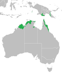
Description: Rangemap of Banksia dentata across northern Australia, southern New Guinea and Aru Islands (Trangan). Map adapted from File:Aust-PNG.png and source info from The Banksia Atlas (Australian Flora and Fauna Series Number 8). Canberra: Australian Government Publishing Service. ISBN 0-644-07124-9. published in 1988. p. 89 and George 1981 Banksia monograph p. 276
Title: Banksiadentatarge
Credit: Own work
Author: Casliber
Usage Terms: Creative Commons Attribution-Share Alike 3.0
License: CC BY-SA 3.0
License Link: https://creativecommons.org/licenses/by-sa/3.0
Attribution Required?: Yes
Image usage
The following page links to this image:

All content from Kiddle encyclopedia articles (including the article images and facts) can be freely used under Attribution-ShareAlike license, unless stated otherwise.