
Image: Ballast Point Map 1851
No higher resolution available.
Ballast_Point_Map_1851.jpg (334 × 363 pixels, file size: 47 KB, MIME type: image/jpeg)
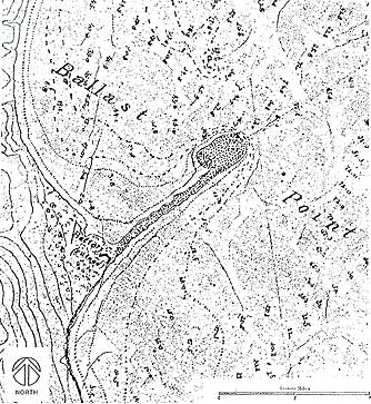
Description: Map of Ballast Point and Fort Guijarros, near present-day San Diego, California, 1851. Caption at source reads, "San Diego Bay, California. “Battery (ruined)”; Enlarged detail of the tracing on the plan table sheet of the San Diego Bay, California. Survey by A.M. Harrison. Source: U.S. Coast Survey, 1851."
Title: Ballast Point Map 1851
Credit: [1]
Author: Uploaded by Johntex
Usage Terms: Public domain
License: Public domain
Attribution Required?: No
Image usage
The following page links to this image:

All content from Kiddle encyclopedia articles (including the article images and facts) can be freely used under Attribution-ShareAlike license, unless stated otherwise.