
Image: Baginbun Head Map

Size of this preview: 800 × 509 pixels. Other resolutions: 320 × 204 pixels | 825 × 525 pixels.
Original image (825 × 525 pixels, file size: 17 KB, MIME type: image/png)
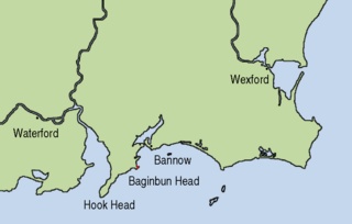
Description: Map showing the location of Baginbun Head where Raymond le Gros landed in 1170 in Ireland. Waterford and Wexford were Norse settlements at that time. The first landing of the Normans took place at Bannow Island in 1169. (This island meanwhile joined the mainland.)
Title: Baginbun Head Map
Credit: This map is based on Image:Topography Ireland.jpg and my own work using Gimp and xfig.
Author: AFBorchert
Usage Terms: Creative Commons Attribution-Share Alike 4.0
License: CC BY-SA 4.0
License Link: https://creativecommons.org/licenses/by-sa/4.0
Attribution Required?: Yes
Image usage
The following 2 pages link to this image:

All content from Kiddle encyclopedia articles (including the article images and facts) can be freely used under Attribution-ShareAlike license, unless stated otherwise.