
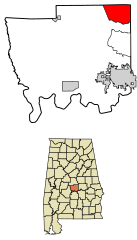
Image: Autauga County Alabama Incorporated and Unincorporated areas Marbury Highlighted 0146600

Size of this PNG preview of this SVG file: 287 × 502 pixels. Other resolution: 137 × 240 pixels.
Original image (SVG file, nominally 287 × 502 pixels, file size: 480 KB)
Description: Location of Marbury in Autauga County, Alabama. FIPS code: 01-46600 Own work, based on concept by Arkyan, using Census Bureau Tiger GIS data and a custom fork of Kartography adapted for this purpose, available at
Title: Autauga County Alabama Incorporated and Unincorporated areas Marbury Highlighted 0146600
Credit: Own work by the original uploader
Author: DemocraticLuntz
Usage Terms: Creative Commons Attribution-Share Alike 4.0
License: CC BY-SA 4.0
License Link: https://creativecommons.org/licenses/by-sa/4.0
Attribution Required?: Yes
Image usage
The following page links to this image:

All content from Kiddle encyclopedia articles (including the article images and facts) can be freely used under Attribution-ShareAlike license, unless stated otherwise.