
Image: Arshakuni Armenia 150-en

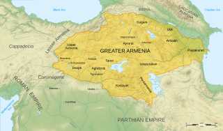
Description: Map of Arshakuni Armenia, around the year 150 AD.
Title: Arshakuni Armenia 150-en
Credit: Own work. Sources : Topographic background : NASA Shuttle Radar Topography Mission (SRTM3 v.2) (public domain) Map of Armenia : Image:ArshakuniArmenia150.gif by Eupator, under license « Public Domain » Rivers : Demis Scale : Image:Scale_kilometres_miles_svg.svg by Sémhur, under license « Public Domain » Software used : NASA data edited with Global Mapper 9 # (limited version), by the United States Geological Survey (USGS) Demis data edited with Demis Mapper Vectorized with Inkscape Cartographic tutorial (in french) by Sting Autres données : projection cartographique UTM Système géodésique WGS84
Author: Sémhur
Usage Terms: Free Art License
License: FAL
License Link: http://artlibre.org/licence/lal/en
Attribution Required?: Yes
Image usage
The following 3 pages link to this image:
