
Image: Arnhem Map 1

Size of this preview: 800 × 529 pixels. Other resolutions: 320 × 212 pixels | 2,000 × 1,323 pixels.
Original image (2,000 × 1,323 pixels, file size: 1.03 MB, MIME type: image/jpeg)
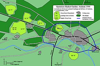
Description: Map of 1st Airborne Division's planned occupation of Arnhem during Operation Market Garden.
Title: Arnhem Map 1
Credit: Own work based on information from: Frost, Major General John (2002) [First published in 1980] A Drop Too Many, Cassell, p. 213 ISBN: 0-85052-927-1. Margery, Karel (2008) [First published in 2002] Operation Market Garden: Then and Now, Battle of Britain International Limited, p. 34 ISBN: 1-870067-39-8.
Author: Ranger Steve (talk)
Usage Terms: Creative Commons Attribution-Share Alike 3.0
License: CC BY-SA 3.0
License Link: https://creativecommons.org/licenses/by-sa/3.0
Attribution Required?: Yes
Image usage
The following 2 pages link to this image:

All content from Kiddle encyclopedia articles (including the article images and facts) can be freely used under Attribution-ShareAlike license, unless stated otherwise.