
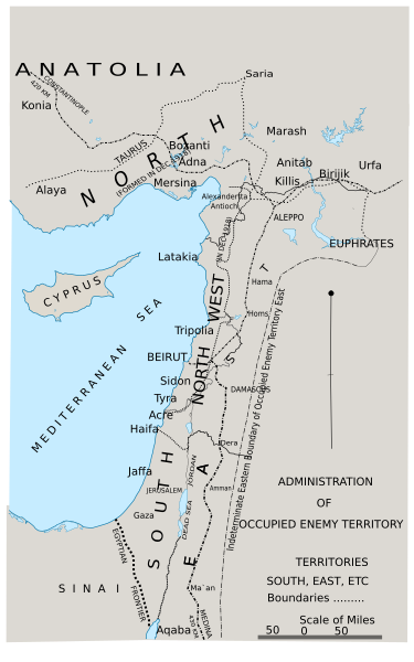
Image: Area of the OETA

Size of this PNG preview of this SVG file: 375 × 600 pixels. Other resolution: 150 × 240 pixels.
Original image (SVG file, nominally 1,500 × 2,400 pixels, file size: 87 KB)
Description: Administration of occupied territory in SVG
Title: Area of the OETA
Credit: Official History of the Great War Based on Official Documents by Direction of the Historical Section of the Committee of Imperial Defence; Military Operations Egypt & Palestine from June 1917 to the End of the War Vol. 2 Part II From File:FallsSkMap42Admin.jpeg
Author: SPQR10
Usage Terms: Creative Commons Attribution-Share Alike 4.0
License: CC BY-SA 4.0
License Link: https://creativecommons.org/licenses/by-sa/4.0
Attribution Required?: Yes
Image usage
The following 2 pages link to this image:

All content from Kiddle encyclopedia articles (including the article images and facts) can be freely used under Attribution-ShareAlike license, unless stated otherwise.