
Image: AnnotatedChartOfStJohns1798

Size of this preview: 800 × 553 pixels. Other resolutions: 320 × 221 pixels | 3,421 × 2,365 pixels.
Original image (3,421 × 2,365 pixels, file size: 4.09 MB, MIME type: image/jpeg)
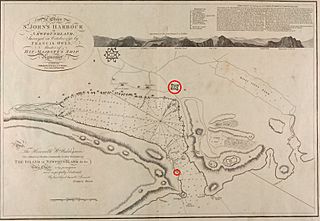
Description: A 1798 map of St. John's, Newfoundland. It has been annotated to highlight Fort William and the South Castle, locations important in battles for St. John's during the War of the Spanish Succession.
Title: AnnotatedChartOfStJohns1798
Credit: Memorial University: http://collections.mun.ca/u?/maps,161
Author: Francis Owen; annotations by User:Magicpiano
Usage Terms: Public domain
License: Public domain
Attribution Required?: No
Image usage
The following page links to this image:

All content from Kiddle encyclopedia articles (including the article images and facts) can be freely used under Attribution-ShareAlike license, unless stated otherwise.