
Image: Amphoe Phetchabun
No higher resolution available.
Amphoe_Phetchabun.png (320 × 445 pixels, file size: 18 KB, MIME type: image/png)
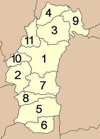
Description: Map of the province Phetchabun with the districts (Amphoe) numbered. Mueang Phetchabun (อำเภอเมืองเพชรบูรณ์) Chon Daen (อำเภอชนแดน) Lom Sak (อำเภอหล่มสัก) Lom Kao (อำเภอหล่มเก่า) Wichian Buri (อำเภอวิเชียรบุรี) Si Thep (อำเภอศรีเทพ) Nong Phai (อำเภอหนองไผ่) Bueng Sam Phan (อำเภอบึงสามพัน) Nam Nao (อำเภอน้ำหนาว) Wang Pong (อำเภอวังโป่ง) Khao Kho (อำเภอเขาค้อ)
Title: Amphoe Phetchabun
Credit: Own work
Author: Ahoerstemeier
Usage Terms: Creative Commons Attribution-Share Alike 3.0
License: CC-BY-SA-3.0
License Link: http://creativecommons.org/licenses/by-sa/3.0/
Attribution Required?: Yes
Image usage
The following page links to this image:

All content from Kiddle encyclopedia articles (including the article images and facts) can be freely used under Attribution-ShareAlike license, unless stated otherwise.