
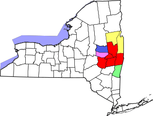
Image: Albany-Schenectady-Amsterdam CSA

Description: Locator map of the Albany-Schenectady-Amsterdam Combined Statistical Area in the eastern part of the U.S. state of New York. The five components of the CSA are colored separately: Albany-Schenectady-Troy Metropolitan Statistical Area Glens Falls Metropolitan Statistical Area Hudson Micropolitan Statistical Area Gloversville Micropolitan Statistical Area Amsterdam Micropolitan Statistical Area
Title: Albany-Schenectady-Amsterdam CSA
Credit: Raster work modified from this United States Census Bureau file, based on the following Census definitions lists: Metropolitan Statistical Areas Micropolitan Statistical Areas Combined Statistical Areas SVG Vectorized from File:Albany-Schenectady-Amsterdam CSA.png
Author: ZooFari
Permission: See below
Usage Terms: Public domain
License: Public domain
Attribution Required?: No
Image usage
The following 2 pages link to this image:
