
Image: Abbasid Samarra Map

Size of this PNG preview of this SVG file: 313 × 599 pixels. Other resolution: 125 × 240 pixels.
Original image (SVG file, nominally 383 × 733 pixels, file size: 398 KB)
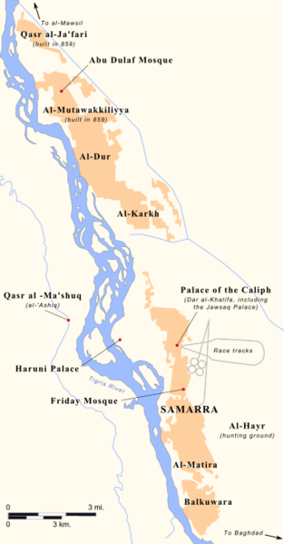
Description: Map of Abbasid Samarra in the mid-ninth century AD. This is primarily based on the work of Alastair Northedge, The historical topography of Samarra (2005), along with subsidiary works in Hugh Kennedy, When Baghdad Ruled the Modern World (2006) and Matthew Gordon, The Breaking of a Thousand Swords (2001).
Title: Abbasid Samarra Map
Credit: Own work
Author: Ro4444
Usage Terms: Creative Commons Attribution-Share Alike 3.0
License: CC BY-SA 3.0
License Link: https://creativecommons.org/licenses/by-sa/3.0
Attribution Required?: Yes
Image usage
The following 2 pages link to this image:

All content from Kiddle encyclopedia articles (including the article images and facts) can be freely used under Attribution-ShareAlike license, unless stated otherwise.