Ill (France) facts for kids
Quick facts for kids Ill |
|
|---|---|

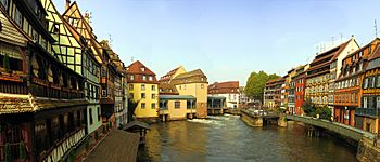
The Ill in the Petite France quarter of Strasbourg. The river's only lock can be seen right of centre.
|
|
| Country | France |
| Physical characteristics | |
| Main source | Jura mountains 570 m (1,870 ft) |
| River mouth | Rhine |
| Length | 223 km (139 mi) |
| Basin features | |
| Basin size | 4,760 km2 (1,840 sq mi) |
The Ill is a river in Alsace, in north-eastern France. It is a left bank, or western tributary of the Rhine. It is 223 kilometres (139 mi) long.
It starts down from its source near the village of Winkel, in the Jura mountains, before meeting with the Rhine downstream from Gambsheim's lock.
As the Ill nears the city of Mulhouse, most of its flow is diverted into a discharge channel leading to the Doller, protecting the historical center of the town from floods.
Flowing through the city of Strasbourg, the river forms part of the 17th-century fortifications and passes through a series of locks and channels in the picturesque old town, including the Petite France quarter, where its waters were once used to power mills and tanneries.
Images for kids
See also
 In Spanish: Río Ill para niños


