Ibaraki Prefecture facts for kids
Quick facts for kids Ibaraki Prefecture |
|||||||||
|
|||||||||
 |
|||||||||
| Capital | Mito | ||||||||
| Region | Kantō | ||||||||
| Island | Honshu | ||||||||
| Governor | Kazuhiko Ōigawa | ||||||||
| Area (rank) | 6,095.58 km² (23rd) | ||||||||
| - % water | 4.8% | ||||||||
| Population (September 1, 2010) | |||||||||
| - Population | 2,964,141 (11th) | ||||||||
| - Density | 486.28 /km² | ||||||||
| Districts | 7 | ||||||||
| Municipalities | 44 | ||||||||
| ISO 3166-2 | JP-08 | ||||||||
| Website | |||||||||
| Prefectural Symbols | |||||||||
| - Flower | Rose (Rosa) | ||||||||
| - Tree | Ume tree (Prunus mume) | ||||||||
| - Bird | Eurasian Skylark (Alauda arvensis) | ||||||||
| - Fish | |||||||||
 Symbol of Ibaraki Prefecture |
|||||||||
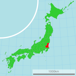
Ibaraki Prefecture (茨城県, Ibaraki-ken) is a prefecture in the Kantō region of Japan on the island of Honshu. The capital is Mito.
Contents
History
In 1871, Ibaraki Prefecture was created from Hitachi Province.
Geography
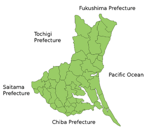
Ibaraki Prefecture is the northeastern part of Kantō. It is between Tochigi Prefecture and the Pacific Ocean. Fukushima Prefecture is its neighbor to the north and Chiba Prefecture is to the south. Saitama Prefecture is to the southwest. There are many mountains in the northern part of the prefecture. The rest of the prefecture is a flat plain with many lakes.
Cities
There are thirty-two cities in Ibaraki Prefecture:
Towns and villages
Towns and villages in each district:
|
|
|
National Parks
National Parks are established in about 15% of the total land area of the prefecture.
Shrines and Temples
Kashima jinja are the chief Shinto shrines (ichinomiya) in the prefecture.
Related pages
- Provinces of Japan
- Prefectures of Japan
- List of regions of Japan
- List of islands of Japan
- Kashima Antlers
- Mito Hollyhock
Images for kids
-
Lake Kasumigaura in Ushibori Village (Hitachi Province), Mount Fuji in the background; 19th century of the Edo period. Hokusai, painter and printmaker
See also
 In Spanish: Prefectura de Ibaraki para niños


