Howey-in-the-Hills, Florida facts for kids
Quick facts for kids
Howey-in-the-Hills, Florida
|
|
|---|---|
| Town of Howey-in-the-Hills | |

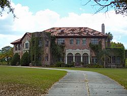
Howey Mansion, original home of the town's founder
|
|

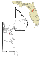
Location in Lake County and the state of Florida
|
|
| Country | |
| State | |
| County | |
| Incorporated (Town of Howey) | May 8, 1925 |
| Incorporated (Town of Howey-in-the-Hills) | 1927 |
| Government | |
| • Type | Council-Manager |
| Area | |
| • Total | 3.67 sq mi (9.51 km2) |
| • Land | 3.16 sq mi (8.19 km2) |
| • Water | 0.51 sq mi (1.32 km2) |
| Elevation | 89 ft (27 m) |
| Population
(2020)
|
|
| • Total | 1,643 |
| • Density | 519.77/sq mi (200.70/km2) |
| Time zone | UTC-5 (Eastern (EST)) |
| • Summer (DST) | UTC-4 (EDT) |
| ZIP code |
34737
|
| Area code(s) | 352 |
| FIPS code | 12-32775 |
| GNIS feature ID | 2405870 |
Howey-In-The-Hills is a town in Lake County, Florida, United States. The population was 1,643 at the 2020 census. It is part of the Orlando–Kissimmee–Sanford Metropolitan Statistical Area.
History
Howey-in-the-Hills was founded by William John Howey, a citrus grower and real-estate developer. On May 8, 1925, Howey-in-the-Hills was incorporated as the Town of Howey. In 1927, the name was officially changed to the Town of Howey-in-the-Hills, to reflect the location of the town in an area of rolling hills.
The first citrus juice plant in Florida was built in Howey-in-the-Hills by William John Howey in 1921.
Geography
The approximate coordinates for the Town of Howey-in-the-Hills is located in central Lake County at 28°42′58″N 81°46′28″W / 28.71611°N 81.77444°W (28.716221, –81.774540).
It sits on the west shore of Little Lake Harris, an arm of Lake Harris. The town is bordered to the northwest by the unincorporated community of Yalaha.
Florida State Road 19 passes through the town, and is locally known as Palm Avenue. It leads north across Little Lake Harris and leads 8 miles (13 km) to Tavares, the Lake county seat. To the south SR 19 leads 13 miles (21 km) to Groveland.
According to the United States Census Bureau, Howey-in-the-Hills has a total area of 3.7 square miles (9.5 km2), of which 3.2 square miles (8.2 km2) are land and 0.50 square miles (1.3 km2), or 13.9%, are water.
Climate
The climate in this area is characterized by hot, humid summers and generally mild winters. According to the Köppen climate classification, the Town of Howey-in-the-Hills has a humid subtropical climate zone (Cfa).
Demographics
| Historical population | |||
|---|---|---|---|
| Census | Pop. | %± | |
| 1930 | 338 | — | |
| 1940 | 203 | −39.9% | |
| 1950 | 188 | −7.4% | |
| 1960 | 402 | 113.8% | |
| 1970 | 466 | 15.9% | |
| 1980 | 626 | 34.3% | |
| 1990 | 724 | 15.7% | |
| 2000 | 956 | 32.0% | |
| 2010 | 1,098 | 14.9% | |
| 2020 | 1,643 | 49.6% | |
| U.S. Decennial Census | |||
2010 and 2020 census
| Race | Pop 2010 | Pop 2020 | % 2010 | % 2020 |
|---|---|---|---|---|
| White (NH) | 1,006 | 1,261 | 91.62% | 76.75% |
| Black or African American (NH) | 14 | 94 | 1.28% | 5.72% |
| Native American or Alaska Native (NH) | 0 | 8 | 0.00% | 0.49% |
| Asian (NH) | 6 | 15 | 0.55% | 0.91% |
| Pacific Islander or Native Hawaiian (NH) | 0 | 0 | 0.00% | 0.00% |
| Some other race (NH) | 0 | 5 | 0.00% | 0.30% |
| Two or more races/Multiracial (NH) | 11 | 36 | 1.00% | 2.19% |
| Hispanic or Latino (any race) | 61 | 224 | 5.56% | 13.63% |
| Total | 1,098 | 1,643 |
As of the 2020 United States census, there were 1,643 people, 715 households, and 547 families residing in the town.
As of the 2010 United States census, there were 1,098 people, 484 households, and 336 families residing in the town.
See also
 In Spanish: Howey-in-the-Hills para niños

