Honomu, Hawaii facts for kids
Quick facts for kids
Honomu, Hawaii
Honomū
|
|
|---|---|

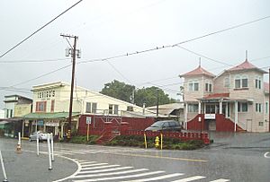
Honomu during rainstorm, 2008. The building to the right is the Köyasan Shingon Mission
|
|
![Location in Hawaiʻi County and the state of [[Hawaiʻi]]](/images/thumb/1/1c/Hawaii_County_Hawaii_Incorporated_and_Unincorporated_areas_Honomu_Highlighted.svg/300px-Hawaii_County_Hawaii_Incorporated_and_Unincorporated_areas_Honomu_Highlighted.svg.png)
Location in Hawaiʻi County and the state of [[Hawaiʻi]]
|
|
| Country | United States |
| State | Hawaiʻi |
| County | Hawaiʻi |
| Area | |
| • Total | 0.49 sq mi (1.26 km2) |
| • Land | 0.46 sq mi (1.18 km2) |
| • Water | 0.03 sq mi (0.07 km2) |
| Elevation | 300 ft (90 m) |
| Population
(2020)
|
|
| • Total | 452 |
| • Density | 989.06/sq mi (382.21/km2) |
| Time zone | UTC-10 (Hawaii–Aleutian) |
| ZIP code |
96728
|
| Area code(s) | 808 |
| FIPS code | 15-17450 |
| GNIS feature ID | 0359354 |
Honomū (Hawaiian: Honomū) is a census-designated place (CDP) in Hawaii County, Hawaii, United States. The population was 509 at the 2010 census, down from 541 at the 2000 census.
Contents
Geography
Honomū is located on the northeast side of the island of Hawaii at 19°52′17″N 155°07′01″W / 19.871390°N 155.117067°W. Hawaii Route 19 passes through the community, leading northwest 31 miles (50 km) to Honokaa and south 11 miles (18 km) to Hilo. Hawaii Route 220 leads southwest from Route 19 through the center of Honomu 3.8 miles (6.1 km) to its terminus at Akaka Falls State Park.
According to the United States Census Bureau, the CDP has a total area of 0.50 square miles (1.3 km2), of which 0.03 square miles (0.07 km2), or 5.83%, are water.
Demographics
| Historical population | |||
|---|---|---|---|
| Census | Pop. | %± | |
| 2020 | 452 | — | |
| U.S. Decennial Census | |||
Places of worship
The Köyasan Shingon Mission of Hawaii is based in Honomu.
See also
 In Spanish: Honomu para niños

