Honaunau-Napoopoo, Hawaii facts for kids
Quick facts for kids
Honaunau-Napo’opo’o, Hawaii
Hōnaunau-Nāpōʻopoʻo
|
|
|---|---|

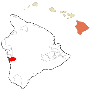
Location in Hawaii County and the state of Hawaii
|
|
| Country | United States |
| State | Hawaii |
| County | Hawaiʻi |
| Area | |
| • Total | 41.89 sq mi (108.49 km2) |
| • Land | 38.01 sq mi (98.43 km2) |
| • Water | 3.88 sq mi (10.06 km2) |
| Elevation | 750 ft (230 m) |
| Population
(2020)
|
|
| • Total | 2,416 |
| • Density | 63.57/sq mi (24.54/km2) |
| Time zone | UTC−10 (Hawaii-Aleutian) |
| Area code(s) | 808 |
| FIPS code | 15-16160 |
| GNIS feature ID | 2414045 |
Hōnaunau-Nāpōʻopoʻo (Hawaiian: Hōnaunau-Nāpōʻopoʻo) is a census-designated place (CDP) in Hawaiʻi County, Hawaii, United States. The population was 2,416 at the 2020 census.
Contents
Geography
Hōnaunau-Nāpōʻopoʻo is located on the west side of the island of Hawaiʻi at 19°26′45″N 155°53′14″W / 19.445961°N 155.887090°W. It is bordered to the north by the Captain Cook CDP and to the west by the Pacific Ocean. It contains the unincorporated community of Hōnaunau in the southwest corner of the CDP, on Hōnaunau Bay, and Nāpōʻopoʻo in the northwest corner, on Kealakekua Bay.
Hawaii Route 11 is the main road through the CDP, leading north 16 miles (26 km) to Kailua-Kona and south 43 miles (69 km) to Nāʻālehu. Hawaii Route 160 winds downhill from Route 11 to connect the communities of Hōnaunau and Nāpōʻopoʻo.
According to the United States Census Bureau, the Honaunau-Napoopoo CDP has a total area of 40.7 square miles (105.4 km2), of which 38.0 square miles (98.4 km2) are land and 2.7 square miles (7.0 km2), or 6.66%, are water.
Nāpōʻopoʻo has a tropical monsoon climate (Köppen Am) with uniformly warm temperatures year-round.
Climate
The climate data for Hōnaunau-Nāpōʻopoʻo is retrieved from the Desert Research Institute's Western Regional Climate Center.
| Climate data for Nāpōʻopoʻo | |||||||||||||
|---|---|---|---|---|---|---|---|---|---|---|---|---|---|
| Month | Jan | Feb | Mar | Apr | May | Jun | Jul | Aug | Sep | Oct | Nov | Dec | Year |
| Mean daily maximum °F (°C) | 80.2 (26.8) |
80.2 (26.8) |
80.6 (27.0) |
81.2 (27.3) |
81.3 (27.4) |
81.8 (27.7) |
83.1 (28.4) |
84.1 (28.9) |
83.9 (28.8) |
83.4 (28.6) |
82.2 (27.9) |
80.5 (26.9) |
81.9 (27.7) |
| Mean daily minimum °F (°C) | 60.6 (15.9) |
60.4 (15.8) |
60.5 (15.8) |
61.8 (16.6) |
62.8 (17.1) |
64.0 (17.8) |
64.1 (17.8) |
65.2 (18.4) |
64.8 (18.2) |
64.4 (18.0) |
63.3 (17.4) |
61.3 (16.3) |
62.8 (17.1) |
| Average rainfall inches (mm) | 2.52 (64) |
1.92 (49) |
2.68 (68) |
3.19 (81) |
3.54 (90) |
3.23 (82) |
3.76 (96) |
3.84 (98) |
4.07 (103) |
3.25 (83) |
2.49 (63) |
2.08 (53) |
36.57 (930) |
| Source: WRCC | |||||||||||||
Demographics
| Historical population | |||
|---|---|---|---|
| Census | Pop. | %± | |
| 2020 | 2,416 | — | |
| U.S. Decennial Census | |||
Education
Hawaiʻi Department of Education operates public schools. Hōnaunau Elementary School is in the CDP.
See also
 In Spanish: Honaunau-Napoopoo para niños


