Homestake Pass facts for kids
Quick facts for kids Homestake Pass |
|
|---|---|

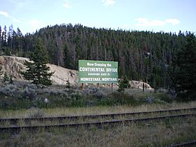
Marker placed along the former Northern Pacific Railway’s crossing of Homestake Pass.
|
|
| Elevation | 1,929 m (6,329 ft) |
| Traversed by | |
| Location | Jefferson / Silver Bow counties, Montana, US |
| Range | Rocky Mountains |
| Coordinates | 45°55.3′N 112°25.2′W / 45.9217°N 112.4200°W |
Homestake Pass is a mountain pass in the Rocky Mountains of Montana in the United States. It sits on the Continental Divide on the border between Jefferson County and Silver Bow County, six miles south-southeast of Butte in Beaverhead-Deerlodge National Forest at an elevation of 6,329 feet (1,929 m). The pass carries Interstate 90 across the Continental Divide and is the highest point on the 3,020 mi (4,861 km) highway.
The pass was discovered by Edwin Harrison McHenry, a civil engineer working for the Northern Pacific Railway, who was tasked with locating a route for the NP from the main line near Logan, Montana through to Butte. The line over the pass from Logan to Garrison, Montana via Butte became the Rocky Mountain Division, Second and Fourth Subdivisions, built in 1889. This was Northern Pacific's scenic transcontinental passenger train route used by the famous North Coast Limited and its Amtrak successor, the North Coast Hiawatha, which was discontinued in 1979. The line over the pass is currently owned by BNSF Railway. It has been inactive since 1983, as its grades and curvature are poorly suited to freight trains, which (now operated by Montana Rail Link) utilize the former Northern Pacific's easier route via Helena, crossing the Mullan Pass. It is unlikely that the rail line over the pass will ever be used again, but BNSF has resisted tearing out the line because the original lease with the Northern Pacific and the US Forest Service requires that the grade be returned to its original status, a very costly process.
When Interstate 90 was built, the state of Montana used Homestake Pass to cross the Continental Divide, thereby providing an easier alternative to the US Route 10 route over the Divide at Pipestone Pass.

