Hindustan, Indiana facts for kids
Quick facts for kids
Hindustan, Indiana
|
|
|---|---|

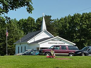
Hindustan Christian Church
|
|
| Country | United States |
| State | Indiana |
| County | Monroe |
| Township | Washington |
| Elevation | 853 ft (260 m) |
| Time zone | UTC-5 (Eastern (EST)) |
| • Summer (DST) | UTC-4 (EDT) |
| ZIP code |
47408
|
| Area code(s) | 812, 930 |
| FIPS code | 18-34042 |
| GNIS feature ID | 436233 |
Hindustan is an unincorporated community in Washington Township, Monroe County, in the U.S. state of Indiana.
History
Hindustan was platted on August 18, 1853, by Charles G. Carr. The community took its name after India (Hindustan) "...or a region of it." Documents dating from the 1870s spell the town's name as 'Hindostan'.
Geography
Hindustan is located at an altitude of 271 metres (892 feet) along Old State Road 37 between Chambers Pike and Farr Road. It is within the Morgan Monroe State Forest.

All content from Kiddle encyclopedia articles (including the article images and facts) can be freely used under Attribution-ShareAlike license, unless stated otherwise. Cite this article:
Hindustan, Indiana Facts for Kids. Kiddle Encyclopedia.


