Hawkins County, Tennessee facts for kids
Quick facts for kids
Hawkins County
|
|||
|---|---|---|---|
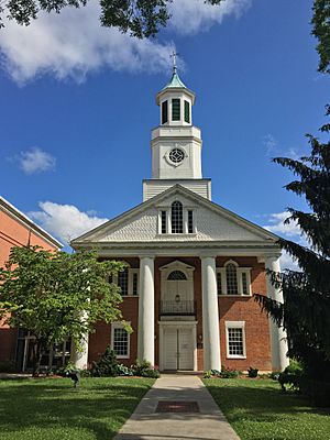
The Hawkins County Courthouse in Rogersville, built c. 1836, is the oldest courthouse in Tennessee
|
|||
|
|||

Location within the U.S. state of Tennessee
|
|||
 Tennessee's location within the U.S. |
|||
| Country | |||
| State | |||
| Founded | 1787 | ||
| Named for | Benjamin Hawkins | ||
| Seat | Rogersville | ||
| Largest city | Church Hill | ||
| Area | |||
| • Total | 500 sq mi (1,000 km2) | ||
| • Land | 487 sq mi (1,260 km2) | ||
| • Water | 13 sq mi (30 km2) 2.5%% | ||
| Population
(2020)
|
|||
| • Total | 56,721 |
||
| • Density | 117/sq mi (45/km2) | ||
| Time zone | UTC−5 (Eastern) | ||
| • Summer (DST) | UTC−4 (EDT) | ||
| Congressional district | 1st | ||
Hawkins County is a county located in the U.S. state of Tennessee. As of the 2020 census, the population was 56,721. Its county seat is Rogersville. Hawkins County is part of the Metropolitan Statistical Area, which is a component of the Johnson City-Kingsport-Bristol, TN-VA Combined Statistical Area, commonly known as the "Tri-Cities" region.
Contents
History
The land was given to William Armstrong as a land grant in the 1780s. Armstrong built Stony Point. Armstrong's landholding was established as a county in 1787. It was named for Benjamin Hawkins, a U.S. Senator from North Carolina, the state which it was a part of at that time. In 1797, Louis Philippe (who would become King of the French in 1830) visited Armstrong's estate.
During the American Civil War, Hawkins County saw combat. The Battle of Rogersville took place on November 6, 1863.
Since the 1940s, a 1,900-2,200 acre area western Hawkins County was proposed and planned as state park known as Poor Valley State Park in order to promote economic development efforts in the upper East Tennessee region, the plan would stall in the 1970s.
Geography
According to the U.S. Census Bureau, the county has a total area of 500 square miles (1,300 km2), of which 487 square miles (1,260 km2) is land and 13 square miles (34 km2) (2.5%) is water.
Adjacent counties
- Scott County, Virginia (north)
- Sullivan County (east)
- Washington County (southeast)
- Greene County (south)
- Hamblen County and Grainger County (southwest)
- Hancock County (west)
State protected area
- Kyles Ford Wildlife Management Area (part)
Other protected area
- Bays Mountain Park (part)
Other historic sites
- Amis House
Demographics
| Historical population | |||
|---|---|---|---|
| Census | Pop. | %± | |
| 1800 | 6,563 | — | |
| 1810 | 7,643 | 16.5% | |
| 1820 | 10,949 | 43.3% | |
| 1830 | 13,683 | 25.0% | |
| 1840 | 15,035 | 9.9% | |
| 1850 | 13,370 | −11.1% | |
| 1860 | 16,162 | 20.9% | |
| 1870 | 15,837 | −2.0% | |
| 1880 | 20,610 | 30.1% | |
| 1890 | 22,246 | 7.9% | |
| 1900 | 24,267 | 9.1% | |
| 1910 | 23,587 | −2.8% | |
| 1920 | 22,918 | −2.8% | |
| 1930 | 24,117 | 5.2% | |
| 1940 | 28,523 | 18.3% | |
| 1950 | 30,494 | 6.9% | |
| 1960 | 30,468 | −0.1% | |
| 1970 | 33,726 | 10.7% | |
| 1980 | 43,751 | 29.7% | |
| 1990 | 44,565 | 1.9% | |
| 2000 | 53,563 | 20.2% | |
| 2010 | 56,833 | 6.1% | |
| 2020 | 56,721 | −0.2% | |
| U.S. Decennial Census 1790-1960 1900-1990 1990-2000 2010-2014 |
|||
2020 census
| Race | Number | Percentage |
|---|---|---|
| White (non-Hispanic) | 52,824 | 93.13% |
| Black or African American (non-Hispanic) | 671 | 1.18% |
| Native American | 104 | 0.18% |
| Asian | 256 | 0.45% |
| Pacific Islander | 13 | 0.02% |
| Other/Mixed | 1,964 | 3.46% |
| Hispanic or Latino | 889 | 1.57% |
As of the 2020 United States census, there were 56,721 people, 23,135 households, and 15,917 families residing in the county.
2010 census
As of the 2010 United States Census, there were 56,833 people living in the county. 96.5% were White, 1.3% Black or African American, 0.5% Asian, 0.2% Native American, 0.4% of some other race and 1.1% of two or more races. 1.2% were Hispanic or Latino (of any race). 47.0% were of American, 9.0% English, 8.0% German and 7.4% Irish ancestry.
Economy
According to a data profile produced by the Tennessee Department of Economic and Community Development in 2018, the top employers in the county are:
| # | Employer | # of Employees |
|---|---|---|
| 1 | Hawkins County Board of Education | 1,100 |
| 2 | BAE Systems Inc. | 850 |
| 3 | AGC Flat Glass North America, Inc. | 550 |
| 4 | Barrette Outdoor Living, Inc. | 500 |
| 5 | Cooper-Standard Automotive | 450 |
| 6 | Hutchinson Sealing Systems | 370 |
| 7 | TRW Automotive | 335 |
| 8 | Walmart (Kingsport) | 300 |
| 9 | Sam Dong, Inc. | 215 |
| 10 | Baldor Electric Company | 207 |
Transportation
Major highways
State Route 172 formerly went into Hawkins County, it now ends in Greene County at Interstate 81 exit 36 in the town of Baileyton.
Airports
The Hawkins County Airport is a county-owned public-use airport located six nautical miles (7 mi, 11 km) northeast of the central business district of Rogersville.
Communities
Cities
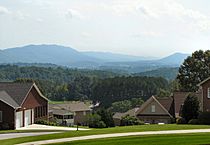
- Church Hill
- Kingsport (partial)
Towns
- Bean Station (partial, mostly in Grainger)
- Bulls Gap
- Mount Carmel
- Rogersville (county seat)
- Surgoinsville
Census-designated place
Unincorporated communities
Education
School districts include:
- Hawkins County School District
- Kingsport City School District
- Rogersville City Schools (elementary only, with secondary students going to Hawkins County schools)
See also
 In Spanish: Condado de Hawkins para niños


