Hart County, Kentucky facts for kids
Quick facts for kids
Hart County
|
|
|---|---|

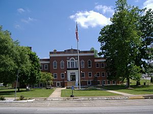
Hart County Courthouse in Munfordville
|
|

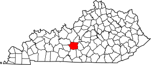
Location within the U.S. state of Kentucky
|
|
 Kentucky's location within the U.S. |
|
| Country | |
| State | |
| Founded | 1819 |
| Named for | Nathaniel G. S. Hart |
| Seat | Munfordville |
| Largest city | Horse Cave |
| Area | |
| • Total | 418 sq mi (1,080 km2) |
| • Land | 412 sq mi (1,070 km2) |
| • Water | 5.8 sq mi (15 km2) 1.4%% |
| Population
(2020)
|
|
| • Total | 19,288 |
| • Estimate
(2023)
|
19,724 |
| • Density | 46.14/sq mi (17.816/km2) |
| Time zone | UTC−6 (Central) |
| • Summer (DST) | UTC−5 (CDT) |
| Congressional district | 2nd |
Hart County is a county located in the south central portion of the Commonwealth of Kentucky. As of the 2020 census, the population was 19,288. Its county seat is Munfordville, its largest city is Horse Cave. Hart County is a prohibition or dry county.
Contents
History
Hart County was formed in 1819 from portions of Hardin and Barren counties. The county is named for Captain Nathaniel G. S. Hart, a Kentucky militia officer in the War of 1812 who was wounded at the Battle of Frenchtown and died in the Massacre of the River Raisin.
The Battle of Munfordville, a Confederate victory, was fought in the county in 1862, during the American Civil War.
A courthouse fire in January 1928 resulted in the loss of some county records.
In 1989 the Amish settlement near Munfordville was founded. It has ties to the Geauga Amish settlement in Ohio, from where many of the Munfordville Amish came. It is the fastest growing Amish settlement in America and had 14 church districts and a total population of about 1,800 people as of 2013[update].
Geography
According to the United States Census Bureau, the county has a total area of 418 square miles (1,080 km2), of which 412 square miles (1,070 km2) is land and 5.8 square miles (15 km2) (1.4%) is water.
Fauna
A female wolf shot in 2013 in Hart County by a hunter was the first gray wolf seen in Kentucky in modern times.
Adjacent counties
- Hardin County (north/EST Border)
- LaRue County (northeast/EST Border)
- Green County (east)
- Metcalfe County (southeast)
- Barren County (south)
- Edmonson County (southwest)
- Grayson County (northwest)
Natural features
A portion of Mammoth Cave National Park and the cave for which it is named is located in western Hart County.
The Fisher Ridge Cave System is located in Hart County. As of 2018[update] it has been mapped to a length of 125 miles (201 km) and is the fifth-longest cave in the United States and the tenth-longest cave in the world.
Demographics
| Historical population | |||
|---|---|---|---|
| Census | Pop. | %± | |
| 1820 | 4,184 | — | |
| 1830 | 5,191 | 24.1% | |
| 1840 | 7,031 | 35.4% | |
| 1850 | 9,093 | 29.3% | |
| 1860 | 10,348 | 13.8% | |
| 1870 | 13,687 | 32.3% | |
| 1880 | 17,133 | 25.2% | |
| 1890 | 16,439 | −4.1% | |
| 1900 | 18,390 | 11.9% | |
| 1910 | 18,173 | −1.2% | |
| 1920 | 18,544 | 2.0% | |
| 1930 | 16,169 | −12.8% | |
| 1940 | 17,239 | 6.6% | |
| 1950 | 15,321 | −11.1% | |
| 1960 | 14,119 | −7.8% | |
| 1970 | 13,980 | −1.0% | |
| 1980 | 15,402 | 10.2% | |
| 1990 | 14,890 | −3.3% | |
| 2000 | 17,445 | 17.2% | |
| 2010 | 18,199 | 4.3% | |
| 2020 | 19,288 | 6.0% | |
| 2023 (est.) | 19,724 | 8.4% | |
| U.S. Decennial Census 1790-1960 1900-1990 1990-2000 2010-2020 |
|||
As of the census of 2000, there were 17,445 people, 6,769 households, and 4,812 families residing in the county. The population density was 42 per square mile (16/km2). There were 8,045 housing units at an average density of 19 per square mile (7.3/km2). The racial makeup of the county was 92.58% White, 6.20% Black or African American, 0.22% Native American, 0.11% Asian, 0.03% Pacific Islander, 0.18% from other races, and 0.69% from two or more races. 0.86% of the population were Hispanic or Latino of any race.
There were 6,769 households, out of which 32.60% had children under the age of 18 living with them, 56.80% were married couples living together, 10.40% had a female householder with no husband present, and 28.90% were non-families. 25.30% of all households were made up of individuals, and 12.00% had someone living alone who was 65 years of age or older. The average household size was 2.54 and the average family size was 3.05.
In the county, the population was spread out, with 25.70% under the age of 18, 8.60% from 18 to 24, 28.20% from 25 to 44, 23.50% from 45 to 64, and 13.90% who were 65 years of age or older. The median age was 37 years. For every 100 females there were 96.90 males. For every 100 females age 18 and over, there were 93.20 males.
The median income for a household in the county was $25,378, and the median income for a family was $31,746. Males had a median income of $26,994 versus $19,418 for females. The per capita income for the county was $13,495. About 18.60% of families and 22.40% of the population were below the poverty line, including 28.40% of those under age 18 and 22.00% of those age 65 or over.
Amish settlement
The Amish settlement in Hart County mainly between Munfordville and Horse Cave was founded in 1989. It has ties to the Geauga Amish settlement in Ohio, from where many of the Hart County Amish came. It is the fastest-growing Amish settlement in America and had 14 church districts and a total population of about 1,800 as of 2013[update]. According to ARDA,in 2020,the Amish population was 2,486 or 12.9% of the total population.[1]
Religion
Religion in Hart County,according to ARDA (2020) Evangelical Churches (28.5%) Anabaptist Church ( Amish) (12.9%) Mainline Protestant Churches (4%) Catholic Church (0.8%) Others (0.9%) None * (52.9%)
*"Nones" is an unclear category. It is a heterogenous group of the not religious and intermittently religious. Researchers argue that most of the "Nones" should be considered "unchurched", rather than objectively nonreligious; especially since most "Nones" do hold some religious-spiritual beliefs and a notable amount participate in behaviors. For example, 72% of American "Nones" believe in God or a Higher Power.
Communities
Cities
- Horse Cave
- Munfordville (county seat)
Census-designated place
Other unincorporated places
- Bee
- Big Windy
- Bonnieville
- Bunnell Crossing
- Canmer
- Cash
- Cub Run
- Eudora
- Hammonville
- Jonesville
- Legrande
- Linwood
- Lone Star
- Monroe
- Northtown
- Pascal
- Priceville
- Rowletts
- Seymour
- Three Springs
- Uno
- Woodsonville
Education
School districts include:
- Caverna Independent School District
- Hart County School District
See also
 In Spanish: Condado de Hart (Kentucky) para niños


