Harrington, New South Wales facts for kids
Quick facts for kids HarringtonNew South Wales |
|||||||||
|---|---|---|---|---|---|---|---|---|---|

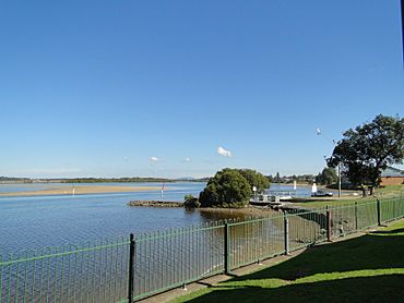
Manning River at Harrington
|
|||||||||
| Population | 3,381 (2021 census) | ||||||||
| Postcode(s) | 2427 | ||||||||
| Elevation | 6 m (20 ft) | ||||||||
| Location |
|
||||||||
| LGA(s) | Mid-Coast Council | ||||||||
| State electorate(s) | Port Macquarie | ||||||||
| Federal Division(s) | Lyne | ||||||||
|
|||||||||
Harrington is a fishing village located on the northern entrance of the Manning River in New South Wales, Australia. It was established in 1853 and proclaimed a village on 26 September 1896. It is 15 km north-east of Taree on the Mid North Coast, and 335 kilometres (208 mi) north east of the state capital, Sydney. At the 2021 census, Harrington had a population of 3,381. It was named after the Earl of Harrington by the explorer, John Oxley.
| Historical population | ||
|---|---|---|
| Year | Pop. | ±% |
| 1966 | 543 | — |
| 1971 | 608 | +12.0% |
| 1976 | 896 | +47.4% |
| 1981 | 1,183 | +32.0% |
| 1986 | 1,234 | +4.3% |
| 1991 | 1,414 | +14.6% |
| 1996 | 1,397 | −1.2% |
| 2001 | 1,412 | +1.1% |
| 2006 | 1,753 | +24.2% |
| 2011 | 2,257 | +28.8% |
| 2016 | 2,896 | +28.3% |
| 2021 | 3,240 | +11.9% |
| Source: Australian Bureau of Statistics data. | ||
Schools
- Harrington Public School
Emergency Services
- Marine Rescue Crowdy Harrington
- SES
- RFS

All content from Kiddle encyclopedia articles (including the article images and facts) can be freely used under Attribution-ShareAlike license, unless stated otherwise. Cite this article:
Harrington, New South Wales Facts for Kids. Kiddle Encyclopedia.

