Hardwicke Bay, South Australia facts for kids
This page is about the locality in South Australia. For the nearby bay, see Hardwicke Bay.
Quick facts for kids Hardwicke BaySouth Australia |
|||||||||||||||
|---|---|---|---|---|---|---|---|---|---|---|---|---|---|---|---|

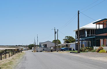
A seaside street in Hardwicke Bay
|
|||||||||||||||
| Established | 1999 | ||||||||||||||
| Postcode(s) | 5575 | ||||||||||||||
| Time zone | ACST (UTC+9:30) | ||||||||||||||
| • Summer (DST) | ACST (UTC+10:30) | ||||||||||||||
| Location |
|
||||||||||||||
| LGA(s) | Yorke Peninsula Council | ||||||||||||||
| Region | Yorke and Mid North | ||||||||||||||
| County | Fergusson | ||||||||||||||
| State electorate(s) | Narungga | ||||||||||||||
| Federal Division(s) | Grey | ||||||||||||||
|
|||||||||||||||
|
|||||||||||||||
| Footnotes | Climate Coordinates Adjoining localities |
||||||||||||||
Hardwicke Bay is a locality in the Australian state of South Australia located on the west coast of Yorke Peninsula overlooking the bay also named Hardwicke Bay about 104 kilometres (65 miles) west of the Adelaide city centre and about 9 kilometres (5.6 miles) north of the town of Warooka.
The boundaries of the locality were created on 27 May 1999 for the “long established name” and including the two shack sites known respectively as the “original shack site” and the “Moorowie Shack Site.”
Hardwicke Bay is located within the federal Division of Grey, the state electoral district of Narungga and the local government area of the Yorke Peninsula Council.
The majority land use within the locality is “primary production.”

All content from Kiddle encyclopedia articles (including the article images and facts) can be freely used under Attribution-ShareAlike license, unless stated otherwise. Cite this article:
Hardwicke Bay, South Australia Facts for Kids. Kiddle Encyclopedia.

