Hagues Peak facts for kids
Quick facts for kids Hagues Peak |
|
|---|---|

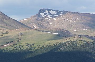
Hagues Peak viewed from Trail Ridge Road
|
|
| Highest point | |
| Elevation | 13,573 ft (4,137 m) |
| Prominence | 2,420 ft (738 m) |
| Isolation | 15.70 mi (25.27 km) |
| Listing |
|
| Geography | |
| Location | Rocky Mountain National Park, High point of Larimer County, Colorado, United States |
| Parent range | Mummy Range |
| Topo map | USGS 7.5' topographic map Trail Ridge, Colorado |
| Climbing | |
| Easiest route | hike |
Hagues Peak is the highest summit of the Mummy Range in the Rocky Mountains of North America. The 13,573-foot (4,137 m) thirteener is in the Rocky Mountain National Park Wilderness, 9.9 miles (15.9 km) northwest (bearing 318°) of the Town of Estes Park, Colorado, United States. Hagues Peak is the highest point in Larimer County, Colorado.
Mountain
Hagues Peak is named after geologists James and Arnold Hague, who surveyed the area in the late 1800s. Fairchild Mountain is about 1.4 miles (2.3 km) to the southwest, while Mummy Mountain is about 1.4 miles (2.3 km) to the southeast. The Rowe Glacier lies about 300 yards (270 m) north of the mountain.

All content from Kiddle encyclopedia articles (including the article images and facts) can be freely used under Attribution-ShareAlike license, unless stated otherwise. Cite this article:
Hagues Peak Facts for Kids. Kiddle Encyclopedia.

