Guthrie County, Iowa facts for kids
Quick facts for kids
Guthrie County
|
|
|---|---|

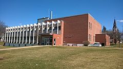
Guthrie County Courthouse
|
|

Location within the U.S. state of Iowa
|
|
 Iowa's location within the U.S. |
|
| Country | |
| State | |
| Founded | 1851 |
| Seat | Guthrie Center |
| Largest city | Guthrie Center |
| Area | |
| • Total | 593 sq mi (1,540 km2) |
| • Land | 591 sq mi (1,530 km2) |
| • Water | 2.5 sq mi (6 km2) 0.4% |
| Population
(2020)
|
|
| • Total | 10,623 |
| • Density | 17.914/sq mi (6.917/km2) |
| Time zone | UTC−6 (Central) |
| • Summer (DST) | UTC−5 (CDT) |
| Congressional district | 3rd |
Guthrie County is a county located in the U.S. state of Iowa. As of the 2020 census, the population was 10,623. The county seat is Guthrie Center. The county was formed on January 15, 1851, and named after Captain Edwin B. Guthrie, who died in the Mexican–American War.
Guthrie County is one of the six counties that make up the Des Moines–West Des Moines, Iowa Metropolitan Statistical Area.
Contents
Geography
According to the U.S. Census Bureau, the county has a total area of 593 square miles (1,540 km2), of which 591 square miles (1,530 km2) is land and 2.5 square miles (6.5 km2) (0.4%) is water.
Example of native vegetation: https://commons.wikimedia.org/wiki/File:Whiterock_Conservancy_Neighborhood_New_Wiki_Version.JPG
Major highways
Adjacent counties
- Greene County (north)
- Dallas County (east)
- Adair County (south)
- Audubon County (west)
- Carroll County (northwest)
Demographics
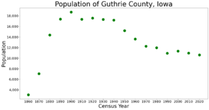
| Historical population | |||
|---|---|---|---|
| Census | Pop. | %± | |
| 1860 | 3,058 | — | |
| 1870 | 7,061 | 130.9% | |
| 1880 | 14,394 | 103.9% | |
| 1890 | 17,380 | 20.7% | |
| 1900 | 18,729 | 7.8% | |
| 1910 | 17,374 | −7.2% | |
| 1920 | 17,596 | 1.3% | |
| 1930 | 17,324 | −1.5% | |
| 1940 | 17,210 | −0.7% | |
| 1950 | 15,197 | −11.7% | |
| 1960 | 13,607 | −10.5% | |
| 1970 | 12,243 | −10.0% | |
| 1980 | 11,983 | −2.1% | |
| 1990 | 10,935 | −8.7% | |
| 2000 | 11,353 | 3.8% | |
| 2010 | 10,954 | −3.5% | |
| 2020 | 10,623 | −3.0% | |
| 2023 (est.) | 10,722 | −2.1% | |
| U.S. Decennial Census 1790-1960 1900-1990 1990-2000 2010-2018 |
|||
2020 census

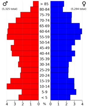
The 2020 census recorded a population of 10,623 in the county, with a population density of 17.8659/sq mi (6.8981/km2). 96.86% of the population reported being of one race. 91.86% were non-Hispanic White, 0.34% were Black, 2.58% were Hispanic, 0.22% were Native American, 0.36% were Asian, 0.15% were Native Hawaiian or Pacific Islander and 4.50% were some other race or more than one race. There were 5,773 housing units, of which 4,529 were occupied.
2010 census
The 2010 census recorded a population of 10,954 in the county, with a population density of 18.5463/sq mi (7.1608/km2). There were 5,756 housing units, of which 4,544 were occupied.
Communities
Cities
Townships
- Baker Township
- Bear Grove Township
- Beaver Township
- Cass Township
- Dodge Township
- Grant Township
- Highland Township
- Jackson Township
- Orange Township
- Penn Township
- Richland Township
- Seely Township
- Stuart Township
- Thompson Township
- Union Township
- Valley Township
- Victory Township
Unincorporated Communities
Census-designated places
- Diamondhead Lake
- Lake Panorama
Population ranking
The population ranking of the following table is based on the 2020 census of Guthrie County.
† county seat
| Rank | City/Town/etc. | Municipal type | Population (2020 Census) |
|---|---|---|---|
| 1 | † Guthrie Center | City | 1,593 |
| 2 | Lake Panorama | CDP | 1,266 |
| 3 | Panora | City | 1,091 |
| 4 | Stuart (partially in Adair County) | City | 1,059 (1,782 total) |
| 5 | Bayard | City | 405 |
| 6 | Diamondhead Lake | CDP | 371 |
| 7 | Casey (partially in Adair County) | City | 368 (387 total) |
| 8 | Menlo | City | 345 |
| 9 | Yale | City | 267 |
| 10 | Bagley | City | 233 |
| 11 | Jamaica | City | 195 |
| 12 | Adair (mostly in Adair County) | City | 18 (791 total) |
| 13 | Coon Rapids (mostly in Carroll County) | City | 0 (1,300 total) |
See also
 In Spanish: Condado de Guthrie para niños


