Great Cockup facts for kids
Quick facts for kids Great Cockup |
|
|---|---|

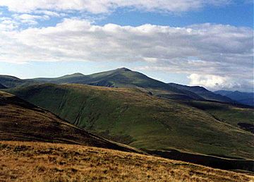
Great Cockup seen from Longlands Fell with the bulk of Skiddaw behind.
|
|
| Highest point | |
| Elevation | 526 m (1,726 ft) |
| Prominence | c. 85 m (279 ft) |
| Parent peak | Knott |
| Listing | Wainwright |
| Geography | |
| Location | Cumbria, England |
| Parent range | Lake District, Northern Fells |
| OS grid | NY273333 |
| Topo map | OS Landranger 89, 90 OS Explorer 4 |
Great Cockup is a fell in the northern region of the English Lake District, one of the four Uldale Fells (the others being Longlands Fell, Great Sca Fell and Meal Fell).
Contents
Description
Great Cockup reaches a height of 526 metres (1,726 ft) and merits a chapter in Alfred Wainwright’s Pictorial Guide to the Lakeland Fells. Wainwright describes the fell as functional rather than ornamental, writing:
‘Viewed from a distance Great Cockup appears as a modest but extensive eminence with no obvious summit and nothing calling for closer inspection. First impressions are confirmed by a tour of exploration, the fell underfoot proving no more attractive than the fell at a distance.’
Etymology
The fell is known as ‘Great’ to distinguish it from its smaller neighbour Little Cockup which lies on its north-western shoulder overlooking the hamlet of Orthwaite with a height of 395 metres (1,296 ft).
The fell’s name originates from the Old English language, a combination of the words cocc and hop, where hop means a secluded valley and cocc means a woodcock or black grouse. So the meaning is probably ‘larger fell above the secluded valley where Woodcock or Black Grouse are found’. Whaley points out that this is the meaning ‘with the valley name being transferred to the hills, but without more evidence this cannot be proven’.
Topography
The fell has a series of stone-built grouse butts 500 metres (1,600 ft) west of the summit, some of which have been dismantled leaving just the foundations in the ground; they can confuse walkers as to their original purpose. The lower southern slope of the fell has a large, isolated boulder which is marked on large-scale maps; this is thought to be an erratic left by a retreating glacier. The fell has also yielded some rare fossils with unusual forms of dendroid graptolites being found on the slopes.
Ascent
Great Cockup is almost always ascended from the hamlet of Orthwaite following the bridleway up Hause Gill for 2 kilometres (1.2 mi) and then leaving it and ascending Great Cockup's steep southern slopes to the summit. A direct ascent over Little Cockup is possible but the bracken can be thick at certain times of the year. Great Cockup is separated from Meal Fell, 1.5 kilometres (0.9 mi) to the east, by the pass of Trusmadoor.
Summit
The view from the summit is dominated by a good view of Skiddaw’s northern slopes while there is an excellent open outlook towards the Scottish Borders.


