Graysville, Tennessee facts for kids
Quick facts for kids
Graysville, Tennessee
|
|
|---|---|
 |
|

Location of Graysville in Rhea County, Tennessee.
|
|
| Country | United States |
| State | Tennessee |
| County | Rhea |
| Named for | William Gray, early settler |
| Area | |
| • Total | 1.18 sq mi (3.05 km2) |
| • Land | 1.18 sq mi (3.05 km2) |
| • Water | 0.00 sq mi (0.00 km2) |
| Elevation | 748 ft (228 m) |
| Population
(2020)
|
|
| • Total | 1,471 |
| • Density | 1,248.73/sq mi (482.25/km2) |
| Time zone | UTC-5 (Eastern (EST)) |
| • Summer (DST) | UTC-4 (EDT) |
| ZIP code |
37338
|
| Area code(s) | 423 |
| FIPS code | 47-30760 |
| GNIS feature ID | 1286033 |
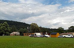
Graysville is a town in Rhea County, Tennessee, United States. The population was 1,471 at the 2020 census and 1,502 at the 2010 census.
Contents
History

Graysville is named for William Gray, an early settler who was appointed postmaster in 1875. The town expanded in the 1880s, when the arrival of the railroad brought coal extraction industries to the area. During this period, the Dayton Coal and Iron Company established a major operation at Graysville. Coal mined nearby was converted into coke, which in turn was used to fuel two blast furnaces to produce pig iron. This operation continued until the Great Depression brought about a general collapse in the industry in the 1930s.
Geography
Graysville is located at 35°26′52″N 85°4′57″W / 35.44778°N 85.08250°W (35.447848, -85.082437). It is situated along Roaring Creek between Walden Ridge (an escarpment of the Cumberland Plateau) and Blackoak Ridge, just north of the Rhea-Hamilton line. U.S. Route 27 passes through the eastern part of Graysville while State Route 303 passes straight through downtown.
According to the United States Census Bureau, the town has a total area of 0.8 square miles (2.1 km2), all of it land.
Demographics
| Historical population | |||
|---|---|---|---|
| Census | Pop. | %± | |
| 1920 | 786 | — | |
| 1930 | 793 | 0.9% | |
| 1940 | 846 | 6.7% | |
| 1950 | 820 | −3.1% | |
| 1960 | 838 | 2.2% | |
| 1970 | 951 | 13.5% | |
| 1980 | 1,380 | 45.1% | |
| 1990 | 1,301 | −5.7% | |
| 2000 | 1,411 | 8.5% | |
| 2010 | 1,502 | 6.4% | |
| 2020 | 1,471 | −2.1% | |
| Sources: | |||
2020 census
| Race | Number | Percentage |
|---|---|---|
| White (non-Hispanic) | 1,286 | 87.42% |
| Black or African American (non-Hispanic) | 14 | 0.95% |
| Native American | 9 | 0.61% |
| Asian | 5 | 0.34% |
| Other/Mixed | 77 | 5.23% |
| Hispanic or Latino | 80 | 5.44% |
As of the 2020 United States census, there were 1,471 people, 669 households, and 428 families residing in the town.
Education
Rhea County Schools is the local school district. Graysville Elementary School is in the community, though it has a Dayton address. The district's sole high school is Rhea County High School.
See also
 In Spanish: Graysville (Tennessee) para niños

